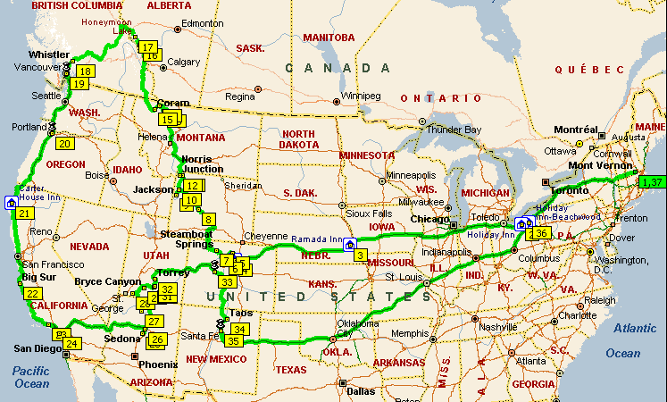
Over the course of six and a half weeks during August and September, 2001, Marina and Park drove over 11,000 miles exploring western US and Canada. We visited with family and friends, revisited locations where we had previously vacationed, and discovered many new spots. We split our time between cities and national parks, staying in campgrounds, homes, hotels, motels, inns and spas.
The weather ranged from very hot and dry, to foggy dampness, to snow (yes, it snowed in Aspen on September 7, the first of the season). We experienced violent thunderstorms in the high peaks of the Rockies, including a hail storm which left an inch of hail on the ground and rushing torrents where there had been a trail 20 minutes earlier. We also had tranquil afternoons soaking in hot tubs overlooking mountains and the ocean. We saw deer, elk, buffalo, mountain goats, bald eagles and numerous small creatures, but no bears. Our elevation ranged from sea level to over 12,000 feet. We crossed the continental divide at least 11 times, not counting hiking on it, and the Colorado River 5 times.
A number of days we found ourselves driving in areas where we would see only one or two cars an hour, and then there was California, where we got to sit with thousands of other cars for hours on more than one occasion. We tried to break up each of our driving days with a few days in one place, and tended to drive 10 - 12 hours between destinations. The longest leg was 1592 miles from Santa Fe to Cleveland: 28 hours with a 2 hour nap and three meal stops. We discovered that we liked more of the country we drove through than we thought we would, with Iowa being the biggest surprise, but there are vast stretches of the high plains that go on much too long.
The map below shows the route we took, with the numbered boxes indicating stops or waypoints. There is a day-by-day description of the trip and what we were up to each day and there is a gallery of over 300 pictures (culled from over 2200!). There's also a topographical version of the map which shows the western part of the route in a bit more detail.
The main gallery page is very large, but you can start browsing once the first picture appears (click on it) and let the other images continue loading in the background. Once you finish viewing a section, close the browser window to get the main gallery page back.
A couple of notes on the pictures: they were all taken with an Olympus C-2100 digital camera, downloaded to a laptop on a daily basis. The pictures were sorted into 17 groups, then we went through each group and tried to select the best dozen or so. The images you'll see here have been reduced from 1600X1200 to 400X300 and compressed to reduce the loading time to around 30 seconds. This is a long-winded way to say I'm not real pleased with the quality of the images shown.