Peaks-Kenny State Park and Gulf Hagas
After the closing on the sale of the house we decided to take off for a few days to decompress. It had
been a particularly stressful time getting the house cleaned up. A major last
minute problem kept us scrambling until the early hours of the 25th - the date
of the closing - getting the house emptied out.
 Peaks-Kenny State Park is a small park in central Maine, about 2 hours from
Portland. North of the park are a number of beautiful areas, including Moosehead
Lake, the Gulf Hagas area, and Mt Katadin. After resting up for a couple of
days we headed off for Gulf Hagas for a little exercise and some sightseeing.
Peaks-Kenny State Park is a small park in central Maine, about 2 hours from
Portland. North of the park are a number of beautiful areas, including Moosehead
Lake, the Gulf Hagas area, and Mt Katadin. After resting up for a couple of
days we headed off for Gulf Hagas for a little exercise and some sightseeing.
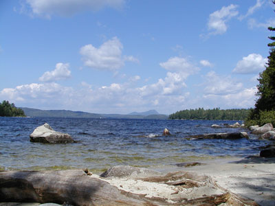
The beach at Peaks-Kenny is a wonderful place and was almost deserted in the
last week of August. The main beach area has a large lawn set back from the
sandy beach and swiming area. To either side of the beach are wooded picnic
areas with wonderful views like the one above.
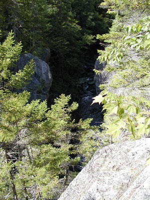
 Gulf Hagas is a large gorge located about an hour and a half north of Dover-Foxcroft,
the town nearest Peaks-Kenny. There is a loop trail which is accessed off the
Appalachain Trail. Half the loop is a strenuous trek which skirts the edge of
the gorge, offering good views of the gorge and the waterfalls and pools it
contains.
Gulf Hagas is a large gorge located about an hour and a half north of Dover-Foxcroft,
the town nearest Peaks-Kenny. There is a loop trail which is accessed off the
Appalachain Trail. Half the loop is a strenuous trek which skirts the edge of
the gorge, offering good views of the gorge and the waterfalls and pools it
contains.
The first hurdle getting to the trail is the Pleasent River. While it lives
up to it's name, it is rather wide at the point when the Appalachain Trail crosses
it and there is no bridge. Fortunatly, the water was low and not too cold, although
it was very rocky - tough on bare feet.
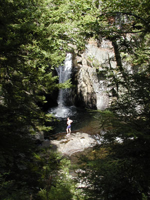
 We got a bit of a late start and didn't realize how long it was going to take
to get to the trailhead. By the time we got on the trail is was approaching
noon. The early portion of the trail was fairly easy going - after crossing
the river - and we though we'd have no trouble completing the loop in spite
of the signs warning us not to underestimate the effort and time required to
hike this 'strenuous' trail. We finally found out what they were talking about
3 miles into the 8 mile round trip. Screw Auger falls (above) was the first
stop of interest along the route, and the largest of the falls we saw.
We got a bit of a late start and didn't realize how long it was going to take
to get to the trailhead. By the time we got on the trail is was approaching
noon. The early portion of the trail was fairly easy going - after crossing
the river - and we though we'd have no trouble completing the loop in spite
of the signs warning us not to underestimate the effort and time required to
hike this 'strenuous' trail. We finally found out what they were talking about
3 miles into the 8 mile round trip. Screw Auger falls (above) was the first
stop of interest along the route, and the largest of the falls we saw.
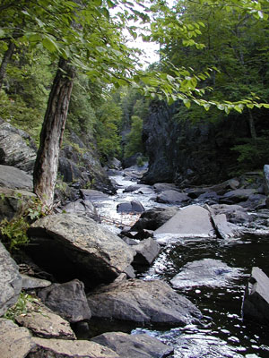
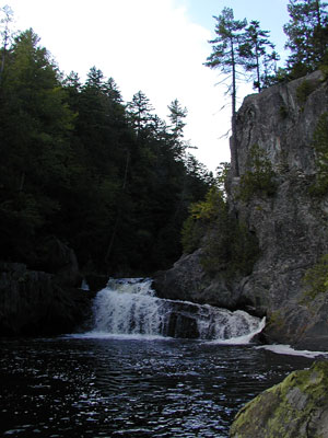 From
Screw Auger Falls the trail proceeds along a canyon, past the lower falls and
cascades before ascending sharply to the rim of the gulf. After that point it
gets pretty tough and our progress slowed considerably. Fortunatly, there are
a couple of cutoffs which allow you to connect to the return portion of the
loop without going to the end. We decided that the second cutoff would be our
target. That allowed us to get as far as Buttermilk Falls where were were able
to enjoy a refreshing swim before heading back.
From
Screw Auger Falls the trail proceeds along a canyon, past the lower falls and
cascades before ascending sharply to the rim of the gulf. After that point it
gets pretty tough and our progress slowed considerably. Fortunatly, there are
a couple of cutoffs which allow you to connect to the return portion of the
loop without going to the end. We decided that the second cutoff would be our
target. That allowed us to get as far as Buttermilk Falls where were were able
to enjoy a refreshing swim before heading back.
The return portion of the trail is well above the gorge and proved to be much
easier going. We made it back in good time, but didn't regret our decision to
forgo the far end of the loop.
Return to the archives